


ste Roseline le peical

vincente204
User
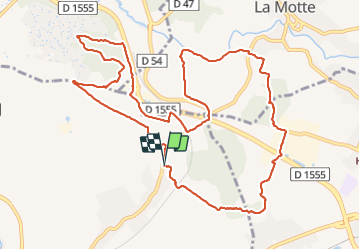

Length
14.5 km

Max alt
190 m

Uphill gradient
251 m
Km-Effort
17.8 km

Min alt
68 m

Downhill gradient
251 m
Boucle
Yes
Creation date :
2022-01-11 07:59:07.99
Updated on :
2022-01-11 13:14:37.038
5h14
Difficulty : Medium

FREE GPS app for hiking
 SityTrail
IGN / Geographical institutes
SityTrail Plus
The world is yours!
About
Trail Walking of 14.5 km to be discovered at Provence-Alpes-Côte d'Azur, Var, Les Arcs-sur-Argens. This trail is proposed by vincente204.
Description
facile
Positioning
Country:
France
Region :
Provence-Alpes-Côte d'Azur
Department/Province :
Var
Municipality :
Les Arcs-sur-Argens
Location:
Unknown
Start:(Dec)
Start:(UTM)
298947 ; 4816434 (32T) N.
Comments